There have been years where the weather speculation thread here has been pretty benign. This is not one of those years. For the first time since 2007, we have the distinct possibility that the race could be materially affected by weather. So here’s a quick recap of where we stand a week out:
- We know it’s going to get warm. The GFS model puts the high temperatures for the next six days at 47, 48, 49, 53, 55, 44; the Euro at 46, 46, 48, 46, 52, 36. Both hint at some rain on Monday. None of this is good: this is enough heat to eat away at the snow base, which is already below average (if there were two feet of snow, it would be fine, but there isn’t).
- The base may survive. It may not. This is really hard to forecast. Slight differences in cloud cover at different times of day, for instance, can make a big difference. This is really a “hope for the best” type of situation.
- There is the potential for a storm next Thursday and Friday. This could be a true Birkie Miracle if it pans out. There are eight long range model runs a day (four GFS, two each from the Canadian and Euro Model) and about 75% of them are showing at least 6″ of snow. (The last several model runs show 10, 8, 11, 1, 16, 7, 5 inches.) There’s even some climatology support: frequently warm spells in the Upper Midwest spawn “panhandle hook” type storms. But this is a long way out, and models are very volatile at this length. The signal is very strong: it’s rare to have such consistency between models and over model runs. (In fact, the “misses” have still shown the storm, but had it pushed south. Every model run for three days has shown the same storm.) But there are no guarantees here. [Update: the latest GFS occludes the storm in Iowa, possibly keeping the Birkie in a warmer sector, but maybe still drops enough snow to get by. It’s still there, so that’s good, I guess. More in the morning.]
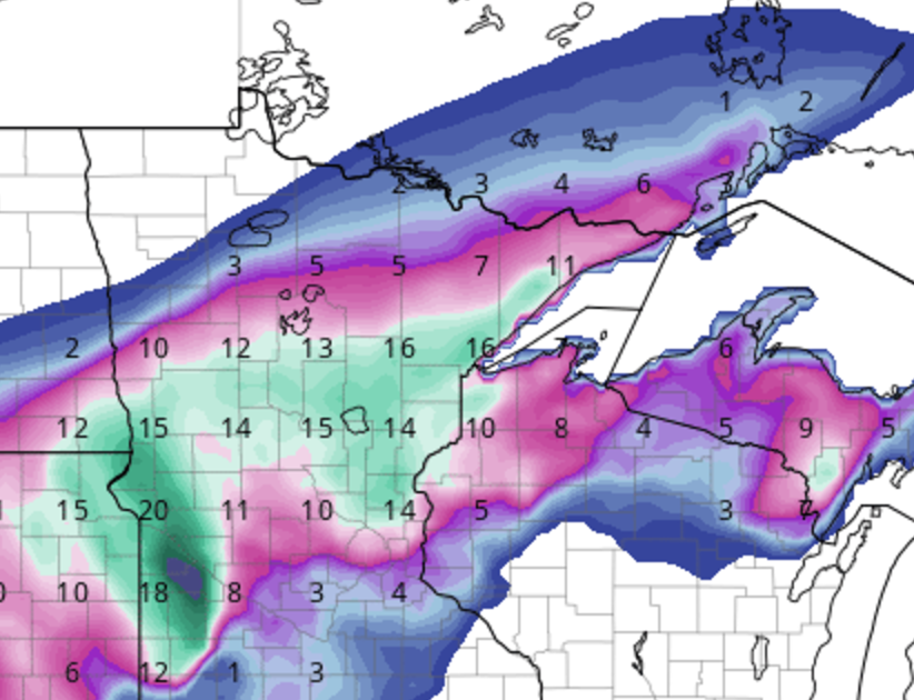
8″ of snow by 7 a.m. on Saturday. Not the best we’ve seen, but we’d take it.
So what does this mean? It means the Birkie could be canceled. I won’t sugarcoat that. Here is my current prediction. First, I’d say there’s a 50% chance this storm materializes and we get enough snow next Friday that it doesn’t really matter if some hills burn out because there’s 6+ inches of new snow to ski on. That would be nice. This is a really high percentage guess for a storm, but it’s rare to see such consistency on the models. If the storm doesn’t materialize, I’d say there’s about a 20% chance that enough snow survives to ski a full course. Another 10% that the course might have to be ended or turned at OO (and I have no idea what this would mean for the Kortelopet). And a 20% chance the race is canceled.
You never want to place so many of your eggs in the basket of “I hope model runs seven days out verify.” This is very risky business. But that’s where we are right now. Our second-best hope is that the upcoming thaw doesn’t melt the trail. And our best hope is for a last-second miracle snowstorm.
To put it another way: it’s the middle of the third quarter and we’re down 28-3. The question is: do we have Tom Brady playing QB? (Yes, I’m an unapologetic Patriots fan. Deal with it.)