Occlusion Collusion may bring race to Conclusion

We’re on to the 00Z model suite (look at me, I almost wrote OOZ, because OO) and the GFS and NAM are both hinting at an earlier occlusion. Basically, the storm would stop intensifying and begin to transfer energy east along an occluded front (or a trough of warm air aloft, or a TROWAL) towards a new triple-point to the east. This may mean that while southwest Minnesota—or even in to the Cities—could see a foot and a half of snow, the Birkie Trail may see only six inches. Six inches may be curtains for the race, especially since much of the trail may be down to bare, warm ground.

This is only one scenario, and there is still the possibility the storm over-performs, and similarly it could go south (as the Canadian continues to suggest). And it’s likely to snow, the question is exactly where and exactly how much. Right now, it doesn’t look like the jackpot will be in Cable. But things can and will change. Many more model runs to go before morning.

The chance of cancelation is too depressing to calculate. It’s well above 50, anyway.

Tuesday afternoon’s grim weather speculation update

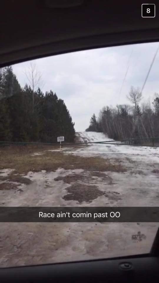
The updates from the race today did not look good. First there was the all-too-green update from Fish Hatchery. Then came the selfie-style video from the Birkie staff office, which almost made this stoic skier cry. Before Ben opened his mouth I knew the news was not good. The trail is down to grass. It will be very hard to hold a race.

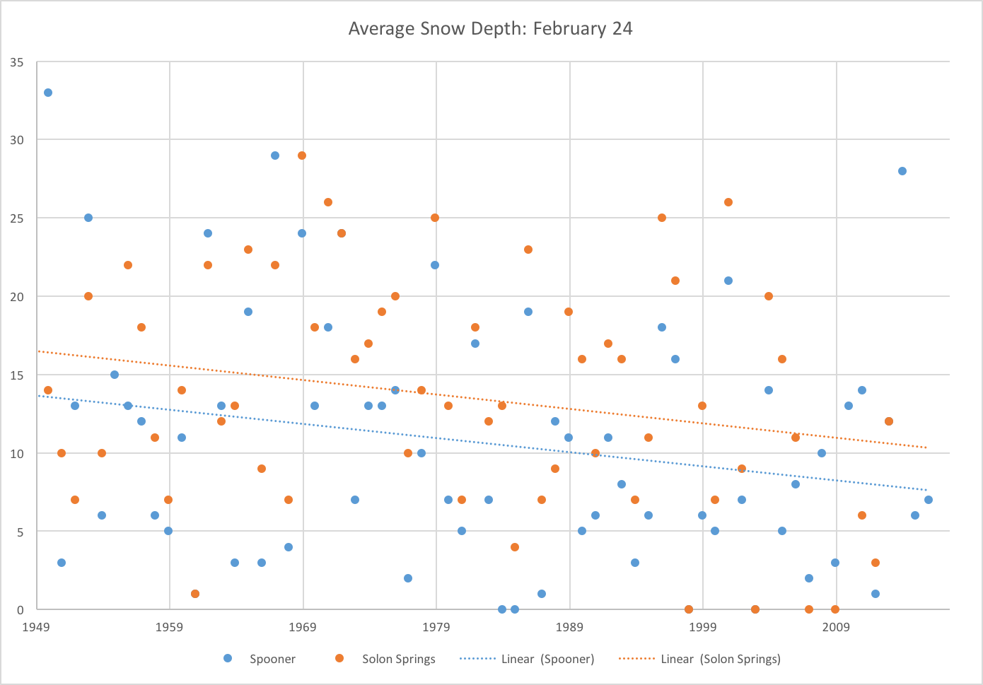
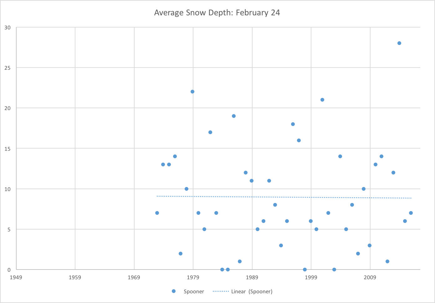
Had some base remained north of OO, things would be different. But the timing of the storm, from a race-organization perspective, is terrible. If the snow fell today, there’d be plenty of time to groom it, let it set up and freeze down, and have a compact base for 10,000 skiers, even with just grass underneath. If it fell on Sunday, it would be too little, too late. As it stands, it’s falling on Friday on to grass. Temperatures will be cold enough that it will freeze in to the soil as it falls, but there won’t be enough time to groom the snow and have it set up in to a solid base, probably unless there is a major shift in the forecast and more than a foot falls. As it stands, forecasts are still in the 3 to 15 inch range, so it could be anywhere from a nothingburger to a big storm.

What seems to be the case is that Ben and the Birkie staff are trying to tamp down expectations. They of course want to have a ski race, but there will be no way to know if there will be enough snow for that until, at the earliest, Friday morning. If they wake up to an all-out blizzard on Friday with temperatures in the low 20s and 10″ of new snow, the groomers might be able to go out and pack the course enough to have a firm enough skate deck for the race on Saturday. (But there’s the issue that for snow falling on warm ground, you don’t want to groom it right away, but you don’t have time to let it firm up instead, because the race is on Saturday.) But if it’s anything less, a few people snowplowing down bobblehead hill will scrape it down to grass for thousands behind, and the already-tricky hill could turn in to a real mess. And certainly not something suitable for a timed race.

Time will tell. But right now, time doesn’t look to be on our side.

The long streak of full Birkies

The Birkie started in 1973. Since then, the race has been altered due to weather nine times. And with news that the lake is out, this year will mark the 10th. However, despite long-term declines in snowpack in northern Wisconsin, the race has just completed its longest streak of consecutive full Birkies in its history:

  • 1973–1980: the race is held for the first eight times. The current trail was not laid out until 1975.
  • 1981: the race is canceled. Elites and international racers ski laps of Mount Telemark. Other skiers return two weeks later when new snow falls.
  • 1983–1985: three straight years where the race fails to reach Hayward, starting twice in Duffy’s Field and once in Rosie’s. (The race was being run northbound at that point.)
  • 1991: The final Hayward-to-Cable race starts in Rosie’s Field, in a snowstorm.
  • 1998: Race is shortened to OO (basically, race becomes the Kortelopet).
  • 2000: Race canceled due to several feet of standing water at the base of some hills.
  • 2002: Race shortened to Rosie’s Field
  • 2007: Race shortened to OO, run as an “open track” event for non-elites. Several inches of snow fell in the evening, but it was not possible to push the race back.
  • 2008–2016: the race is held on a full course for nine years straight, with nearly perfect conditions every year.

Looking at the longer-term trends, this (unfortunately) may be a hard record to crack again. Average snow depth has declined, over the past 70 years, at a rate of about one inch per decade, using snow depth data for Spooner and Solon Springs. Using just data from Spooner since 1973, the trend is flat, but this is rather selective. (I’ll have more of this analysis post-race.)

snowdepth snow_spooner

Let’s hope for as good a Birkie as we can get this year, and for better luck in 2018!

I have to admit, it’s getting better (45% chance of cancelation)


I was pessimistic when I went to bed. I’m optimistic this morning. Everything that came in overnight looks good:

  • The European model trended back to snow. It’s still putting Hayward on the northern fringe, with only about four or five inches (although it does flip Cable over to some wet pasty snow on Wednesday), but that’s a better trend from yesterday when it was showing only an inch or two. So that’s good.
  • The GFS model has held serve and continues to show 8–12 inches falling on Thursday night in to Friday, most in time for the Kortelopet. Again, it could stand to move a few miles north, but I would not complain if it played out just as modeled.
  • The NAM model pushed north overnight, and now outpaces the GFS, showing upwards of a foot of snow falling, with the same time frame.

The noon model suite should tell us more, but for now, this is promising.

An aside: let’s hope that the models which correctly modeled the warm-up almost a month ago do the same with the storm (these are entirely different models). At least starting today.

Getting in range … (49% chance of cancelation)

We’re getting in to the range where more models come in to view for The Storm, namely the NAM at 84 hours.

The news is mixed.

The NAM runs the storm south, but it’s a mid-range model at the outside of its range. Can it be trusted?

The GFS, which had missed “wide right” for several runs, is back. The most recent run brings a solid foot of snow to the Birkie Trail by midnight Saturday, most of it falling on Friday morning, in fact, in time for the Kortelopet. The CMC is south, however, and Euro model isn’t out until later tonight, so we may have a much clearer picture tomorrow morning. No change to the cancelation model. But if the Euro doesn’t come back in to the fold, our hopes will diminish quite quickly.

Livin’ on a prayer (49% chance of cancelation)

Today’s model runs have been … all over the map. The GFS, which had taken snow south of Eau Clare, has brought it back to the Birkie. Not much, but 4″ would be enough as long as the base is somewhat intact.

The European pushed the storm south. The Canadian kept us on the edge.

It doesn’t look good, but it’s not hopeless. A lot will depend on what happens tomorrow with the rain having come through. If the base north of OO (I’ve mostly written off a race south of OO unless the storm comes way north; if Fish Hatchery is hosting a trail run on Thursday, well, that doesn’t bode well) survives, I think we have a decent chance. If there are small holes that can be patched (water courses, etc) I think we might be okay. Having the race on Saturday, after some cold weather sets in, helps a lot: if the race was scheduled for Wednesday we might be sunk. If the course has washed away to grass, though, we’ll really need a miracle.

I’ve updated my numbers. I think we’re really right on a 50/50 line of salvaging anything.

Now, I might have to write my unofficial guide to still having fun at the Birkie even if you only get to ski 25k.

Do you believe in miracles? Not yet …

No lake? No lake. (47% chance of cancelation)

The lake is out.

The lake is a flowage: a dam across a river. If there’s a lot of melt and rain, the lake flows. If the lake flows, the ice becomes unstable, and you don’t exactly want to ski across it. So that has happened.

image1 (1)

This is Wheeler Road down by Duffy’s Field, we think.

Reports from the rest of the trail, at least south of OO, don’t sound so hot, either. Here’s my best guess as to what is going to happen, assuming the north end of the trail is at least mostly intact:

  • The Korteloppet will run from OO to Cable (or Cable to OO, depending on which direction makes the most sense).
  • The Birkie will run from Cable as far south on the trail as is possible, which will likely depend on how much snow (if any) falls on Friday. The latest model runs are all putting the Birkie right on the edge of the storm, so that will be a wait-and-see.

So the news today is … not good. If the storm comes north and drops enough snow, we might do fine. If not, the best we can hope for is a 25k Birkie to OO, much like 2007. In 2007, the storm hit on Saturday night. This year, it comes a day-and-a-half earlier. We’ll keep an eye out on it.

It’s the US vs the World (37% chance of cancelation)

Twice a day, we get three different models at the same time. At noon today, the Canadian and European models looked juicy for the end of the week: snow and cold for the Birkie. The American model? Not so great, again. It is cold for Saturday (and Friday, for that matter), but suppresses the low far south, far enough that the Birkie would see little more than flurries.

The latest from the trail makes me wonder if there’s much of a chance of keeping the snow through the race on much of the trail: two inches has already been lost with four warm days to go. So I’ve upped the cancelation probability to 37% (there’s a formula for this, below), but there’s still a decent chance of having a race.

How do I calculate these guesses? First, I estimate the chance that snow will come and save us. That is calculated by taking the proportion of the models giving us enough snow by Friday evening for a race and dividing it by the model pessimism adjustment rate (generally, 2). So if two of three models give us snow, I give a 33% chance that the snow will save us. Then I take the probability that the whole course will have snow and that just the north end will. Add it all together, subtract from 100, and get a cancelation percent. My guesses right now:

  • Probability of snow: 33%
  • Probability of part of the trail surviving: 30%
  • Probability of the whole trail surviving: 15%
  • Probability of cancelation: 37%

Two out of four (30%)

The overnight model runs are in:

The Euro looks great.

The Canadian looks great.

The American model looks … well, the most recent version brought a bit of snow in, while the midnight run was dry. So maybe that’s the right direction? It at least looks like there will be enough cold air in place for the race that whatever snow is left will be frozen solid. But it would be nice to have something on top.

Waiting … (30% chance of cancelation)

In recent posts I’ve used a football metaphor regarding the chance of a snowstorm saving our behinds for the Birkie. Since it’s 50 in Hayward, here comes a baseball metaphor:

It’s the bottom of the 9th, two out, runner on second, down a run. If we get a double or better (6″ or more) from the storm, the race will be great. A single (3-5″) may be fine, depending on how much base is left, but the runner could get thrown out at the plate. Any kind of out? We’re probably sunk.

Right now, we’re hitting about .500. The most recent models, to go back to football, have been shading towards a miss wide-right, putting snow down in Madison and Chicago but not on the Birkie Trail. But last night the models were missing wide-left, with rain on the Birkie Trail and snow up in the Arrowhead. The weather in Hayward today was warm but dry: so the base probably did okay. But there’s a lot of weather to come.

Some people have emailed me asking about weather models and where I get them, so here you go. For the GFS and CMC, poke around TropicalTidbits and PivotalWeather; you can also view model output at wxweb and the Bufkit Warehouse. The ECMWF is proprietary and you have to pay to access it, and we don’t have enough money for that yet (support our advertisers!) but you can view output from the Norwegian Meteorological Service (long story as to why, and as to why I know) here.