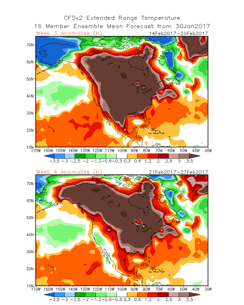
I have to admit, it’s getting better (45% chance of cancelation)


I was pessimistic when I went to bed. I’m optimistic this morning. Everything that came in overnight looks good:

  • The European model trended back to snow. It’s still putting Hayward on the northern fringe, with only about four or five inches (although it does flip Cable over to some wet pasty snow on Wednesday), but that’s a better trend from yesterday when it was showing only an inch or two. So that’s good.
  • The GFS model has held serve and continues to show 8–12 inches falling on Thursday night in to Friday, most in time for the Kortelopet. Again, it could stand to move a few miles north, but I would not complain if it played out just as modeled.
  • The NAM model pushed north overnight, and now outpaces the GFS, showing upwards of a foot of snow falling, with the same time frame.

The noon model suite should tell us more, but for now, this is promising.

An aside: let’s hope that the models which correctly modeled the warm-up almost a month ago do the same with the storm (these are entirely different models). At least starting today.

Getting in range … (49% chance of cancelation)

We’re getting in to the range where more models come in to view for The Storm, namely the NAM at 84 hours.

The news is mixed.

The NAM runs the storm south, but it’s a mid-range model at the outside of its range. Can it be trusted?

The GFS, which had missed “wide right” for several runs, is back. The most recent run brings a solid foot of snow to the Birkie Trail by midnight Saturday, most of it falling on Friday morning, in fact, in time for the Kortelopet. The CMC is south, however, and Euro model isn’t out until later tonight, so we may have a much clearer picture tomorrow morning. No change to the cancelation model. But if the Euro doesn’t come back in to the fold, our hopes will diminish quite quickly.

Livin’ on a prayer (49% chance of cancelation)

Today’s model runs have been … all over the map. The GFS, which had taken snow south of Eau Clare, has brought it back to the Birkie. Not much, but 4″ would be enough as long as the base is somewhat intact.

The European pushed the storm south. The Canadian kept us on the edge.

It doesn’t look good, but it’s not hopeless. A lot will depend on what happens tomorrow with the rain having come through. If the base north of OO (I’ve mostly written off a race south of OO unless the storm comes way north; if Fish Hatchery is hosting a trail run on Thursday, well, that doesn’t bode well) survives, I think we have a decent chance. If there are small holes that can be patched (water courses, etc) I think we might be okay. Having the race on Saturday, after some cold weather sets in, helps a lot: if the race was scheduled for Wednesday we might be sunk. If the course has washed away to grass, though, we’ll really need a miracle.

I’ve updated my numbers. I think we’re really right on a 50/50 line of salvaging anything.

Now, I might have to write my unofficial guide to still having fun at the Birkie even if you only get to ski 25k.

Do you believe in miracles? Not yet …

No lake? No lake. (47% chance of cancelation)

The lake is out.

The lake is a flowage: a dam across a river. If there’s a lot of melt and rain, the lake flows. If the lake flows, the ice becomes unstable, and you don’t exactly want to ski across it. So that has happened.

image1 (1)

This is Wheeler Road down by Duffy’s Field, we think.

Reports from the rest of the trail, at least south of OO, don’t sound so hot, either. Here’s my best guess as to what is going to happen, assuming the north end of the trail is at least mostly intact:

  • The Korteloppet will run from OO to Cable (or Cable to OO, depending on which direction makes the most sense).
  • The Birkie will run from Cable as far south on the trail as is possible, which will likely depend on how much snow (if any) falls on Friday. The latest model runs are all putting the Birkie right on the edge of the storm, so that will be a wait-and-see.

So the news today is … not good. If the storm comes north and drops enough snow, we might do fine. If not, the best we can hope for is a 25k Birkie to OO, much like 2007. In 2007, the storm hit on Saturday night. This year, it comes a day-and-a-half earlier. We’ll keep an eye out on it.

It’s the US vs the World (37% chance of cancelation)

Twice a day, we get three different models at the same time. At noon today, the Canadian and European models looked juicy for the end of the week: snow and cold for the Birkie. The American model? Not so great, again. It is cold for Saturday (and Friday, for that matter), but suppresses the low far south, far enough that the Birkie would see little more than flurries.

The latest from the trail makes me wonder if there’s much of a chance of keeping the snow through the race on much of the trail: two inches has already been lost with four warm days to go. So I’ve upped the cancelation probability to 37% (there’s a formula for this, below), but there’s still a decent chance of having a race.

How do I calculate these guesses? First, I estimate the chance that snow will come and save us. That is calculated by taking the proportion of the models giving us enough snow by Friday evening for a race and dividing it by the model pessimism adjustment rate (generally, 2). So if two of three models give us snow, I give a 33% chance that the snow will save us. Then I take the probability that the whole course will have snow and that just the north end will. Add it all together, subtract from 100, and get a cancelation percent. My guesses right now:

  • Probability of snow: 33%
  • Probability of part of the trail surviving: 30%
  • Probability of the whole trail surviving: 15%
  • Probability of cancelation: 37%

Two out of four (30%)

The overnight model runs are in:

The Euro looks great.

The Canadian looks great.

The American model looks … well, the most recent version brought a bit of snow in, while the midnight run was dry. So maybe that’s the right direction? It at least looks like there will be enough cold air in place for the race that whatever snow is left will be frozen solid. But it would be nice to have something on top.

Waiting … (30% chance of cancelation)

In recent posts I’ve used a football metaphor regarding the chance of a snowstorm saving our behinds for the Birkie. Since it’s 50 in Hayward, here comes a baseball metaphor:

It’s the bottom of the 9th, two out, runner on second, down a run. If we get a double or better (6″ or more) from the storm, the race will be great. A single (3-5″) may be fine, depending on how much base is left, but the runner could get thrown out at the plate. Any kind of out? We’re probably sunk.

Right now, we’re hitting about .500. The most recent models, to go back to football, have been shading towards a miss wide-right, putting snow down in Madison and Chicago but not on the Birkie Trail. But last night the models were missing wide-left, with rain on the Birkie Trail and snow up in the Arrowhead. The weather in Hayward today was warm but dry: so the base probably did okay. But there’s a lot of weather to come.

Some people have emailed me asking about weather models and where I get them, so here you go. For the GFS and CMC, poke around TropicalTidbits and PivotalWeather; you can also view model output at wxweb and the Bufkit Warehouse. The ECMWF is proprietary and you have to pay to access it, and we don’t have enough money for that yet (support our advertisers!) but you can view output from the Norwegian Meteorological Service (long story as to why, and as to why I know) here.

The trend is our … friend? (Cancelation: 30%)

Quick late evening post. The GFS and CMC model runs have come in (I really should post a glossary!) and both are pretty direct hits on Birkieland. The GFS is kind of perfect, it starts snow on Thursday evening and drops nearly two feet by Saturday morning. The Canadian is a bit later and a bit lighter, but still puts down nearly a foot by Birkie o’clock.

Based on this, and how confident Ben Popp is of the base in our podcast, I’m lowering the proprietary-calculation cancelation number to 30%.

(And wouldn’t it be odd if, after stressing out for weeks about the snow, we skied the Birkie on a foot of fresh powder in 10˚ temperatures with whipping winds?)

Screen Shot 2017-02-17 at 11.55.21 PM

Screen Shot 2017-02-17 at 11.55.47 PM

Podcast Episode 7: Ben Popp Updates

The latest episode of the BirkieGuide.com Podcast is dropping (well, uploading) as we speak (especially if I upload them to the right directory). We talk with Ben Popp, the Birkie executive director, about the current status of the course, the chances of a good race, and preparations and contingencies. He’s realistic but optimistic: the base is solid and helped by rain which solidified it in January and earlier this month. He says there’s a 75% chance we survive the meltdown.

(Model update: the latest US model was very bad, but the latest European model very good. It’s wait and see at this point.)

55˚. 36% chance of cancellation

The forecast high in Hayward today was 47˚.

Right now, it’s 55˚.

This is real bad. It’s 55 and sunny, which is better than 55 and rain, but still baking away at the base. The hope was that fog or low clouds would mitigate the melt somewhat. That looks unlikely.

On the other hand, the European model prints out a direct hit for the Birkie next Thursday and Friday with 12-18 inches of snow falling, starting Thursday night. We’re now banking on that. Here’s my best guess at what may happen next week:

  • 6% chance the race is held on the current base
  • 18% chance the race is held on the current base, but is shortened to or turned back at OO
  • 40% chance the race is held based on new snowfall
  • 36% chance the race is canceled due to lack of snow

With the current weather and upcoming warmth, we are really banking on a Birkie Blizzard. It’s not a good place to be. But it’s better than canceling a plane ticket.