Weather spec 2/12

Quick post today because I just got back from a weekend of driving, skiing, and generally freezing to death (at least this afternoon, boom -20 wind chill).

According to the latest GFS model run, there will no snow in the next week with highs topping out in the mid 30s and dry air, so the snow should stay pretty okay. The second week—where of course it is purely guessing—would feature two shots of snow, one warmer storm early in the week with a few inches of wetter snow and a second cooler storm right before race day with a few inches of powder. This would be nice. Race day temps just above 0 with strong northerly winds. Bring out the wind briefs.

The DGEX is in a bit of agreement towards the early part of the long range forecast. The GGEM suppresses the storm track southwards with cool temperatures. The ECMWF is, who knows. The CPC automated forecast (on the weekend, there’s no discussion) is for normal temperatures and above-normal precip for Birkie week. Which hopefully would translate to the four letter S word, not the four letter R word.

In other words, things look pretty okay. The 70-10-10-10 breakdown from the other day holds. By the way, if this all makes very little sense to you, check out the weather speculation resources.

Weather speculation 2/10

First, good news. A cold front kicked up some lake moisture (most years it probably would have passed drier, but Superior isn’t anywhere near frozen) and kicked up some snow in Birkieland. Reports are of 3-4 inches on the trail. Yeah, that’ll help. Also most years we wouldn’t be celebrating a couple inches of snow. But that snow gives some immunity to a quick warm-up, and gives a lot more leeway for rolling and grooming going forwards.

As for the long range forecast, they’ve bounced around a lot, as usual. In the last couple of days they’ve shown rain, snow, warm and cold between now and race day. But for the most part, the next week looks cold to start and warmer to finish, with no real chance of any precipitation. Next week might jump in to the mid 30s a couple of days, but no snow-sapping 50 degree readings are on the horizon. Beyond that, there’s lots of variability, but I’ve not seen a model run in the past 24 hours which would cancel the race (50 and sunny, or warm rain with no new snow) and more than one which would get the course in good shape.

Here’s some pure conjecture (i.e. I’m making up these numbers as I go along): If you’d asked yesterday, I would have given the chances of a full course race at 50%, a modified but nearly full race (at least 40k) at 20%, a shortened race (a la 2007) at 20% and a cancellation at 10%. In the past 24 hours, with a surprise coating of snow, I’d move the numbers to 70-10-10-10. It’s amazing what a couple inches of snow will do.

Finally, the past 24 hours’ model runs show the following conditions for race time. You can see there’s some volatility:

  • 10, cloudy, north winds, possible light snow, new snow before race day
  • 20, calm, clear, new wet snow before race day
  • 30, east wind, damp, new wet snow before race day
  • 15, north wind, mostly cloudy, some new snow before race day

Weather speculation 2/9: First race day “forecast”

Never fall in love with a model run. That said, I love the 12Z GFS model run. It prints out a high temperature in the next two weeks of 33 in Hayward. And it prints out 1.5 inches of liquid equivalent precipitation, which would equate to, oh, a foot and a half of snow. And, 384 hours out, it shows a race-time weather in the single digits, mostly sunny and light winds. As someone whose fastest skis are best on soft, cold snow, this would be fantastic.

Now, let’s not get carried away. Major caveats. First, temperatures early next week are forecast to be near freezing (1000-500 heights near 540; see the Weather Speculation Resources for more information about this), with some sun, so that could be warmer. Which the ECMWF suggests. Which could be, uh, bad. And all of the snow comes in the second half of the model run, which is the wildly variable half. So the next run of the model could show zero precipitation. The weather features it’s prognosticating are the figurative flaps of a butterfly’s wings right now. There’s no way of telling what my come. So the next model run could show the same thing, or it could show no snow at all.

A case in point: in Boston there has been a hint of a coastal storm for the last few days, but it’s been pushing all the snow out to sea. Now the models shifted, and one is showing 8-10 inches, less than 60 hours before the “event.” So things will change. Sometimes for the better. In any case, it’s never a bad thing to see favorable model runs pop up. It’s even better to see continuity. We’ll keep an eye on it and hope for the best.

We’re within 384 hours! We now get a model run that goes out to Birkie every six hours (at least) until race time. It’s not worth losing sleep over, but it’s a little too much fun.

Weather speculation resources

I get excited about the weather, like many skiers, but I am no meteorologist. However, I know that there is a lot of information, and misinformation, out there and I want to share the resources I use to make wildly speculative inferences about the weather. You can use them too.

Most of the information here comes from weather models. Weather models give us a decent idea of what the weather might be in the long term (i.e. whether it will be warm or cold in a week, or stormy or calm), and short term models help us to pinpoint smaller-scale weather features and timing. Here are models and model information, in a generally descending format from longest-range to shortest-notice. There are a bunch of different outputs from the models, especially in the long range (many having to do with aviation such), but we’re only interested in a few, namely:

  • 850 mb temperature. This is the temperature about 5000 feet up in the air. Above 0 C is bad. Below 0 C is better. This does not correlate necessarily with the temperature at the ground, however
  • Surface temperature. This is the temperature at the surface. Got it? 850 mb and surface temperatures sometimes come in to play when discussing precipitation type (i.e. rain, sleet, snow).
  • 1000-500mb thickness. This is a pretty good indicator of whether it will snow or rain (or be warm or cold). 540 is the magic number. Rain > 540, Snow < 540. With some but not too much variability. Cold air is denser, so the thickness is lower. Much more information here.
  • MSLP, or mean sea level pressure. This is an output showing highs and lows, which correlate to storms.
  • Period precipitation. Models usually show precipitation over three- or six-hour periods. Most models have a map showing thickness and precipitation overlaid (and usually MSLP, too) so you can see a) where there is moisture and b) where it’s cold enough to be snow.

A couple notes. Models have numerical output (tables) and graphical output (maps) and I’ll link to whatever I can. Models cycles are updated based on UTC or Zulu (Greenwich Mean) time (usually 00Z, 06Z, 12Z, 18Z), but that doesn’t necessarily correlate with their availability. I’ll mention that. Also, all the abbreviations mean something. No one really knows or cares. Oh, and beyond seven days models vary immensely from run to run, and whatever you can glean from them is, well, not that useful. But fun! On to them:

  • The GFS is the long-range US government model. (And, since it’s the work of the government, it is free! Your tax dollars at work.) It goes out 384 hours, or 16 days. The model itself is here, and a numerical output can be found here. (The link is for Hayward, but replacing KHYR with any other airport, like KMSP, will give data for there.) I usually look at the 100_500_thick link on the model page, and you can then select “loop all”. The GFS is updated at 5 and 11 a.m. and p.m. (all times Central Standard Time; models don’t go on daylight time in March, however).
  • The GGEM is the Canadian’s model. It’s updated twice a day around noon and midnight. The 00Z model run goes out 10 days, and the 12Z goes out seven. Maps can be found here. I generally look at the precipitation output (which includes the 540 thickness line) and the total accumulation. Remember, it’s Canadian. Everything is metric.
  • The ECMWF is the European model. You have to pay money to get that one, and I don’t. However, you can compare it with the GFS for free here (you want the surface pressure comparison), which is a good way to at least see if it’s showing something similar or if it is wildly different. Or, here’s another site I just found. Look at the North America images. The ECMWF updated a bit before 2 a.m. and p.m.
  • The DGEX is a US model which has some interesting outputs, like 6-hour snowfall and total snowfall, which are all available here. It runs from 84 hours (when the NAM, see below, ends) to 192 hours (3.5 to 8 days), and comes out on the 06Z and 18Z cycles, around 6 a.m. and p.m. I also look at the SLP/6 hour precip, which includes the 540 thickness.
  • The NAM runs to 84 hours and has similar attributes to the GFS, but is much finer in scale. Find it here.
  • The WRF model goes to 36 hours here, but I don’t check it often.
  • The HRRR is updated every hour and goes for 15 hours here. Before or during a storm event it is fantastic. It has really interesting attributes and outputs. I’ll mention it more if a miracle storm is upon us.
Now, here are some model-based resources which are not the models themselves, but use the model outputs. These are all based on the US models (GFS, NAM and HRRR)
  • I mentioned the GFS 16 day tables above. Here’s the link for Hayward, and you can put in nearly any airport code to get data for it.
  • A fellow down at Iowa State started something called the Bufkit Warehouse (Bufkit is a snowfall product developed by the … you know what, if you really care, Google it) which plots data for the GFS, NAM and HRRR models out to seven days. By data I mean temperature, precipitation, snowfall and such. It’s great, if a bit finicky. Here’s Hayward; if you want data for elsewhere click here and use the map. One note: the MOS (model output statistics) are viewable here and a better indicator of temperature than the models themselves, which can be important when the model says 33 and the MOS says 42. They only go out a couple of days.
  • Earl Barker’s website is also great. I have not gone through all his maps and data, but his radar site snowfall overlay maps for the GFS and NAM models are very useful. Find them here. Click on Duluth and you’ll see Hayward.
  • The Climate Prediction Center has a good-if-verbose discussion of the model runs for the longer term (6-10, 8-14 day) period which is a good read.
There are also a few non-model items I use. Commercial weather sites are generally worthless, as they repackage weather service products with a bunch of ads. Accuweather has a 15 day forecast which I am convinced does nothing more than grab an output from the GFS for days 8-15 and put up a little picture. Wunderground is decent when the NWS website is down (rare) as you can link to the forecast discussion. As for the National Weather Service, here’s how to use it:
  • Go to weather.gov (also nws.noaa.gov)
  • Click on the area you’re interested in and, on the zoomed in map, the location, or enter an address or ZIP code
  • Look at the forecast.
  • Click on the three day history link to the right of the current conditions (here it is for Hayward; this is where the Birkie pulls data from when the show the current weather)
  • Scroll down to find the radar map (here for Duluth); the only other radar map I use is from Intellicast, the local version is here (okay, so commercial sites aren’t all worthless)
  • And below that there’s a link to the area forecast discussion. Again here’s the one for the Duluth office. The AFD is written pretty cryptically but gives you a really good idea in to the forecaster’s thinking. You can find out if they have a high or low confidence in the forecast, if they’re leaning one way or another as far as different models go. Sometimes you’ll hear the local news meteorologists talking about a huge storm four days out and the forecast discussion will tell you it’s a “low confidence forecast” and that “variability in the track” will play a major role. It’s definitely worth a read. Click on any highlighted “word” for a (sometimes useful) glossary of what it means.
Why do I like the weather service? Because I’m a big government liberal. And because the weather service employs local, experienced meteorologists across the country who are not just getting a forecast ready for the teevee or for their blog. And because they have the discussion. And because they’re not out to make a buck.
I do, however, like some weather bloggers out there. Weather for skiers has some good resources, like John Dee‘s page. The Updraft Blog (from MPR) and Paul Douglas’s blog (Strib) are good too. And the Midwest Climate Watch has good information, too.
Oh, and pray for snow.


Weather speculation: 2/8

It’s barely two weeks to the Birkie, and things seem to be, well, sort of holding on. We’re on the verge of the longest model runs going to race day, so it’s time to start weather speculation in earnest! The news going forward is very mixed. On the one hand, the current models have not been showing any major warm-ups. Without new snow, a couple days in to the 40s would probably shorten the race, and quite possibly cancel it.

The latest model run (in tabular form here and in graphic form here) shows cold temperatures and then moderation this week, and a similar pattern next week. The forecast high over the next two weeks is 36, although that day it appears there may be abundant sunshine which could, in late February, push the mercury over 40 and do a number on some south-facing hills. Precipitation appears negligible, with storms tracking south of the Northwoods, although a shift north would hit Birkieland quite nicely and is not out of the question.

In summary, there’s a decent chance of a full race if temperatures stay low and there’s a bit of new snow. But with trail conditions sounding pretty marginal, any deviation (colder and snowier or warmer and sunnier) will have major implications towards race day. We will, of course, keep you posted.

Here is our post on weather speculation resources.

Weather Speculation: 2/4

This will be the first of many features speculating about the weather upcoming and how it will affect the Birkie. It is all wild speculation, so take it with a grain of salt. Thanks.

What’s the weather? For those of us who get a little too worked up about the Birkie (raise your hands), and especially those of us who are paying a lot of money for plane tickets, this will be a frequent question over the next three weeks. The race is twenty-two days away, and the models only go out sixteen, so there’s no idea of what might be coming down the pike. But, we’re here to speculate wildly! So we will.
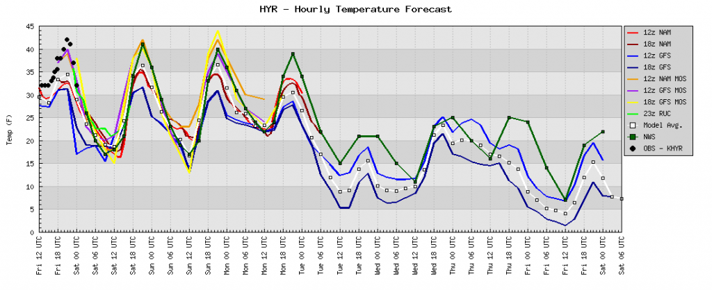
Model print out for Hayward. More information on where to find this model data can be found below.

I mentioned recently that the last week before the race was, in low snow years, make-or-break. This year that may be the case, but the next few days will be pretty important, too. This is because it’s warm in Hayward. Not 50-degrees sweltering hot (which is rare, but not out of the question) but peaking in to the low 40s every day. In late December, that would be a nuisance. But in February, with the sun higher in the sky and getting higher every day, it’s more of a problem. Reports are coming in that some hills are getting thin, as would be expected. I’d assume the Birkie will have a large team out to shovel the hills. So if it hits 42 the next three days (and keeps freezing hard each night) we’re probably safe.

The issue would be losing the base completely. If that were to happen, and for that we’d need several days above freezing, or some rain, or something similarly awful, there would be major issues. The Birkie Trail is grassy and smooth enough that with any base, a couple of inches of new snow can take you from a 2007 rockskivaganza to a picture-perfect race. If you lose that base, however, three inches is not enough to groom and have 8000 skiers glide across it, V1 up and it snowplow it off the hills. If we lose the base, the bar to have a race goes a lot—several inches—higher.

For now we can’t speculate on the last week. Beyond this week, where the base should hold (mostly) we’re probably going to be okay. The long range appears that it will stay cooler, but there is not any big snow on the horizon. Six or eight inches would be great. But it hasn’t been that sort of winter. Yet.

A couple of resources:

The Bufkit Warehouse Meteogram for HYR. A great resource (and the source of the image above) showing, graphically, temperature, snowfall and other such fun things for all the NOAA models. Updated pretty continuously. New NAM (84 hour) models come out at 3 and 9 central, new GFS at 5 and 11. Or a few minutes after. This site was built by a grad student at Iowa State. Who said nothing good comes from Iowa?!

The sixteen day GFS model printout. Also updated at 5 and 11. This shows temperatures and precipitation (but not snow) for 384 hours, or sixteen days. This will hit race day in about a week, but the second week out is really volatile, so take everything with a shaker of salt.

I don’t know whether the weather will be good

So, it’s a month to the Birkie. And the weather is … well, not good. Yes, there’s snow up north. But there’s not that much. There’s no base. And one bout of warm weather could wreak havoc on the Birkie.

We’ve seen this before. In 2000—before I had ever heard of the Birkie (horrors!)—the race succumbed to a warm winter and a warm spell the week before the race. In 2007, the same thing happened, only the race was shortened and run on rock ski conditions to Highway OO (today they might run it back on the classic trail). What will happen this year?

There’s room here for some optimism. First of all, there are good conditions in the Wisconsin north woods. According to Skinnyski, there’s enough snow that the trail has a firm skate deck and classic tracks. It sounds like the race could be run today without much of a hitch, but we’re still four weeks away from race day. Temperatures tomorrow should reach in to the 30s, but then a cool-if-not-cold weather regime should set in, with the possibility of some snow this weekend. But the models this year have been finicky, and there’s not necessarily a good sign that a frigid, snowy weather pattern will set up for February.

And lest we get ahead of ourselves, February 2007 (the last canceled or significantly shortened race) started off nice and cold; temperatures didn’t hit 20 until a week before race day, but peaked at 52 the next week—and no snow fell until the evening after the race. 2000’s data is partially missing, but that year it was also the case that the race was only doomed by warm weather the week preceding. Once we get to within two weeks of the race, this page will speculate on the weather. However, let’s not count any chickens until we have deep snow and cold temperatures the week before the race.