Weather speculation: rain/snow line.

I’ll get this right out there: I’m not very concerned about the Birkie conditions this year. But the weather the week before will be, to use a Upper Midwesternism, interesting.

First thing, the Birkie has, as usual, closed the trail starting at 11:59 p.m. on Sunday night. They want to have the trail cleared for grooming, but they also don’t want anyone putting ruts in a soft trail. And that could be the least of their problems.

I’ll go into some detail below, and stay tuned to The Podcast this weekend for a catch up with Ketzel Levens, who will do some model interpretation for us as well.

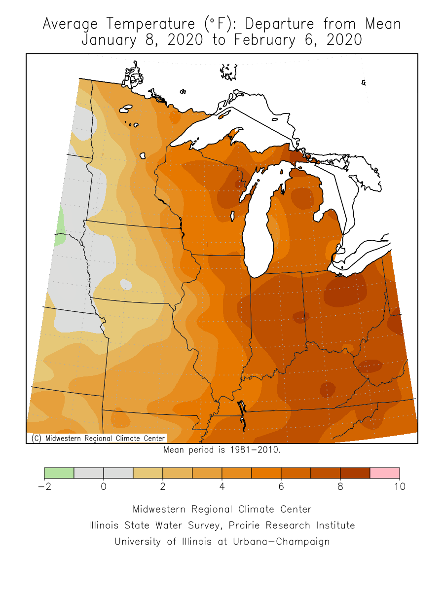
Here’s where we are. For the past couple of months, most of the weather in the Northwoods has been from northern-stream clipper systems, with cold dry air punctuated by light snowfalls. During that same time, out west, there has been scant snowfall. California had some heavy snow around the new year, otherwise, it’s been dry. Alta, for instance, has had its lowest snowfall in more than 20 years. It’s probably good the Olympics aren’t in Salt Lake this year.

But that’s about to change. A series of storms is about to blow into the Sierra, across the Rockies, and then tap into Gulf moisture and stream north and affect the Upper Midwest. The first of these is poised to slam into California on Monday and then reform as a Colorado Low across the Plains by Tuesday, and what falls on the Birkie will be affected by how and where that low forms. Before then, it’s going to be warm, but not too warm, for the next few days, with highs in the low 40s, and lows in the low 20s. Much warmer, and we’d be in deep trouble snowpack-wise, but I think that given the dry weather, light winds and overnight cooling, the snowpack should mostly stay intact, although the Birkie may have to worry about a few south-facing hills with the mid-February sun.

Then the storm ejects across the Midwest. A quick reminder on how weather models work. Weather models divide the atmosphere into a three-dimensional grid, and then take the data of the conditions in that grid and … run with it. This gives a deterministic outcome, based on the initial conditions, it shows a specific outcome (often called the “operational” outcome). Oh and there are AI “models” too, we’ll ignore them for now (they’re not bad, just another tool in the shed). As with any model, this is prone to cascading error based on initialization errors, and since a lot of the data collected is collected by satellite or other measures over the Pacific at this range, we know that there are initialization errors. So weather models then perturb the initial data and run an “ensemble suite” of these perturbations to get an idea of potential outcomes. That’s more useful at this range.

For the Wednesday storm, the models show low pressure tracking anywhere from the Minnesota-Iowa border (or even a bit further south) to Duluth. (Below is the GEFS model from WeatherNerds.com.)
Screenshot 2026-02-12 at 21.18.12

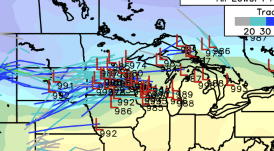
For actual weather, this track matters a lot. A track near Iowa means a snowstorm for the Birkie. A track over Duluth a rainstorm. And somewhere in between, well, somewhere in between. Our friends at the National Weather Service’s Duluth office are predicting “a change of rain or snow” because they’re looking at the same model data that I am.

If we look at some recent deterministic model runs, we see a similar spread. The 18Z GFS model has rain on Wednesday changing to snow accumulating several inches. This would make for a very messy, miserable Open Track on a wet, soft course with rain and wet snow falling, to the point where, if I were the Birkie, I’d consider pushing the Open Track to Thursday. The GFS has 5″ of snow in Hayward, but potentially significantly more in Cable, and more than a foot in Duluth. The Canadian model is a few miles south, with a foot in Hayward, but a sharp cutoff with almost nothing one county south (Rusk). Meanwhile, the European model, which was a northern outlier yesterday, has now pushed south and is showing a more southerly track and snow band, with Hayward on the northern edge of the heaviest snow.

Once this first storm passes, the pattern stays active, but the jet stream pushes south a bit, so it allows colder air to flow in. So as long as there is not a large correction north, which would allow warm rain to fall, there should be cold weather by Thursday morning to freeze up the trail, no matter how much snow falls on top. The Birkie will probably then focus on grooming the southern end for Friday events, and then the whole trail for Saturday, by which time some models suggest there may be more snow.

So if you thought you were going to dial in your wax job this weekend, well, good luck with all that! You can use the code podcast over at PioneerMidwest.com for their race wax service (thanks, Matt, who is right now at the Olympics watching Jessie, but is coming home for The Race). And stay tuned for Ketzel talking weather and probably some classic wax this weekend!

Weather speculation: should we be concerned?

So far this year, the weather in Hayward has been pretty much perfect. December began with a deep freeze to freeze the lakes solid. January was cold and added some snow to the trail. (There was a high of 38 above and a low of 38 below.) There is a compacted base of 8 to 12″ of snow on the trail (and more ice than that on the lake). February has started off a bit warmer, but not anything that would impact the snow.

So far.

But the next week looks dicey. All of the models have some above-freezing temperatures. 40 is fine as long as it gets cold overnight and refreezes (in fact, for the race, it’s probably preferable). What we don’t want is a replay of 2000. That year was looking fine until the week before the race, when a sudden warmup with six straight days in the 40s, and four cracking 50s, canceled the race, and making national news. Apparently there was enough snow some of the race could have occurred, but there was standing water on the trail in several points, the day before the race was warm (in the 40s or higher all day), wet and windy.

So far this year doesn’t look nearly that bad. The next week will be warm. The NWS has four days in the 40s starting on Friday, but these look to be dry and temperatures should fall well below freezing each night. Dry air does not melt snow as quickly as moist air, and overnight temperatures refreeze the snow meaning it takes more energy to warm up before any melts the next day. The day to watch is next Tuesday and Wednesday. A weather system will move across the Northwoods on Tuesday and Wednesday, and its track and strength will determine how much of an issue it is for the race (sorry, Open Track skiers, it might not be a great year for the Open Track event).

If it evolves as the American model suggests, a low pressure center tracks across Iowa and would cool down enough to put some fresh snow on the course, and then draw in cold air afterwards for a good race. The Canadian tracks this feature as a disorganized system across Northwest Wisconsin, and would create some air and warmer temperatures, but would cool it down enough to freeze up for the race (and probably would impact the snow, but not too severely). The European model stalls the low even further northwest, then pivots warm-sector moisture around it to the southeast, still dropping some rain for Birkieland but, again, probably in a time frame where it would refreeze before the race. (It also shows a Birkie blizzard, with several inches of snow falling during the race.)

This warmer forecast is certainly suboptimal, and the groomers may well have their work cut out for them. But as it stands right now, we’re not facing a week of temperatures in the 50s and heavy rain like 2000 or 2017 (or 1981, 1998 or 2002). No model touches 50, let alone shows several days. But that said, we should remain a bit on edge in case it trends to the outside of the envelope of possibility.

So when will the warm-up occur? (#weatherspeculation)

I’m not concerned about a warm-up before race day. The snow that’s there, and whatever falls this weekend, will be there. 2017 this is not. Except for Friday and Saturday, when the temperatures will reach to nearly 20 (balmy!) Hayward shouldn’t break 10 until next Wednesday. Lows most nights will be in the -10 to -20 range, and often colder. We could race in that, but like Bartleby, I’d prefer not to.

Luckily, I don’t think we’ll have to. Take a look at the map below. It shows the temperature outlook for the week starting Thursday before Birkie. Since weather patterns often progress west to east in the US, this suggests that the pattern may start off colder and move towards warmer, and since average high temperatures in Hayward are nearly 30 in late February, we could be looking at near normal temperatures during this range. During a transition from colder temperatures to warmer temperatures, there’s often a departing high pressure system, which can mean cold but calm conditions to start with warm sunshine by afternoon, the perfect weather for the Birkie,.

8 to 14 Day Outlook - Temperature Probability

Reading the model tea leaves, they all suggest this in the longer range, but occurring at different times. The GFS suggests that Friday (Korte Day) would be around -20˚ to start, but “warm up” to nearly 20˚ by afternoon. Birkie day would fall back to 10˚ to 15˚, but make 30˚ by the Lake (this is my favorite Birkie weather). The European and Canadian models shows this happening a day later (with Korte Day barely making it to 10˚, and Birkie Day maybe making it to 20˚). If they’re right you’ll need more Aquavit to stay warm cheering on the lake!

Two weeks to go: looking perfect

Never say never, but I can not see any circumstance right now which would lead to anything other than a picture-perfect postcard race.

I’ll go right out and say it here: there is about as close to a 100% chance that the Birkie will go off on February 22 (and the Korteloppet the day before) as there ever has been.

The last 30 days, temperature-wise, from the MRCC

The last 30 days, temperature-wise, from the MRCC

This is not, however, for atmospheric lack of trying. Much of this decade, winter has been dominated by the (scare voice) polar vortex. As the polar jet stream as weakened, cold air has spilled south to send frigid air to Birkieland and nearby. Some years have stayed cold the whole way through (2014). Some have been variable. Last year January was quite warm overall, even if the second half of the month saw several days staying well below zero. January of 2017 had seven days in Hayward with a high below 10, and this January that happened just once. This year was warmer, overall, than 2017. Yet the highest recorded temperature in January in Hayward this year was just 34, while in 2017 there was a week straight with highs above 38, and several days in the 40s.

In fact, since 1998 (before which there is a gap in record keeping in Hayward), there has been only one other year when the temperature in Hayward has stayed below 35: 2011. Despite being warmer than all but three years of the past 23, January this year stayed just cool enough to keep the snow around. Sure, it reached 34 four days in a row. But 34 doesn’t really melt snow. (Yes, I know, it it 45 earlier this week. But the snow is surviving.)

season.sdevThis year has had a zonal flow, with modified Pacific air predominating with only small blasts of arctic cold. It hasn’t been particularly wet, but there’s no snow drought, either. The snow fell early in Birkieland, and it’s stayed around. Here’s a map of snowfall in the Midwest. See that little dot in the middle of Northern Wisconsin? That’s the Birkie. (Interesting to note, the Keewenaw has seen less snowfall than normal, but the eastern UP a lot more.

So the Birkie has a foot-plus of packed base. What does the next week hold in store? All signs point to more of the same.

More of the same is good. The American model out to the Birkie shows it staying colder than it’s been, with a few days dipping below zero. The European model is a bit warmer, but still keeps Hayward below freezing. Both are reasonably dry. But that means a fast, transformed, set up course, not one the Birkie has to plow with Pisten Bullies the day before the race.

This is definitely something we can get behind!

Weather for race day? Who knows! It’s two weeks out: we can deduce some trends, and make educated guesses. But as usual, the start pen temperature at this point should be somewhere between -15 and 45. 15 above is a pretty good guess. But don’t start panic waxing too quick.

Holding pattern: Pattern holding (weather speculation)

No major chances on Friday morning. 7 days to the Korteloppet, 8 days to the Birkebeiner. Definitely in range.

Cold for the next few days but not frigid. Lows around 0, highs in the teens. The region saw a bit of snow last night, but not another dump, so the groomers should be able to handle it. The next week looks dry and cool, warming a bit later in the week, but in to the 20s during the days, so no big worries. I want to take a second to talk about how well the four-week outlook worked out: it predicted cold and moist, and we got cold and moist (well, cold and moister). Not that we can ever really trust that.

Anyway, there are some hints of some light snow on Wednesday night, but nothing the groomers can’t handle. Then for the race, there are hints of light snow during the race; the models have trended cooler and drier, so I’d be surprised if we see anything too heavy or too wet. Very likely we’re looking at cool but not cold and soft conditions. Still a week out, but things look good. I’m going to round up to say there’s a 100% chance the race is a go.

240 hours from race day: we’re within range for real Weather Speculation

Once we get to 240 hours from an event (that’s 10 days, guys), weather model resolution improves. The US, European and Canadian models all have 6 hour resolution looking out to that time, which gets us to race morning. With a lot of snow on the ground to groom (we have a podcast upcoming on that, stay tuned!) and a cold forecast, we’re not really worried about whether the race will happen, but more of what the course and weather will look like.

As of right now, here’s what we see:

  • Cool but not cold. A few nights below zero, most days in the 10s or 20s.
  • Dry. Likely little or no snowfall in the next week
  • A hint of a storm on Korteloppet Friday

The last one is interesting. All of the models are hinting at the same thing, but 10 days out, take it with several grains of salt. What it looks like right now would be temperatures peaking on Friday around 35, potentially some snow or even rain, and then a cold front sweeping through on Friday night. But it could be 40 and rainy, 20 and snowing, or 0 and clear. That’s anyone’s guess. We’ll know more in the next few days.

Weather Speculation: All signs point to yes

It’s still 18 days until race day, and the Birkie isn’t blanketed with feet upon feet of snow (although a few inches last night helped) but barring any major forecast “busts“, the Birkie should go off as planned.

The snow last night helped a lot; the thinner southern half of the trail needed some more cover and every inch helps, especially since this storm was slightly focused towards the south. Another, bigger storm hits tonight, and current predictions range from 4 to 10 inches by Friday morning. Even the low end of this range would be great, putting down a sum of nearly half a foot this week. Ten inches would be a godsend, adding a foot. (I think the lower end is more likely, but we’ll see).

More importantly, especially now that we’ve taken care of the snowfall, the longer range forecasts look very good. The next four weeks are all showing below average temperatures for Birkieland, and it’s a wide swath of cold, so we’re not really on the edge of it. The 8 to 14 day forecast is just as good: cold and moist; exactly what we’d want. There is a chance that the weekend before the race a storm will sneak a bit of sleet, freezing rain or even rain up to the race, but if we can get six more inches of snow it might be a benefit, adding to the base (it would not likely be all rain) and adding some moisture to make the trail faster. Some of the most fun Birkies of recent years, in 2009 and 2010, were skied on fast snow with some added moisture, “superhero” conditions with great glide and fast times.

Are we out of the woods completely? Of course not. This is weather forecasting, or in this case, speculation. Things can change. But all told, this is a very good place to be. In 2017, I had a “percent chance of cancelation” metric based on current conditions and future forecasts. (This starts around 10%, given that in the past 20 years, two Birkies have been canceled completely.) A week ago, I would have had it at 15%. Today, it’s probably below 5%.

Weather Speculation: Meltdown survival and cold to come

Things look good. The Birkie Trail survived the meltdown (as much as it was one) and a bit of rain/freezing rain and while it may have some thin spots, reports are that it is in good shape.

Looking ahead for the next 10 to 15 days, things look cold. That’s good on it’s own; if it doesn’t go above freezing in the next three weeks, we’ll have a good Birkie. But more importantly, it looks cold with some moisture. A couple of inches Tuesday in to Wednesday, a couple more Thursday in to Friday, and we could be in good shape. We’re not home free until we get a couple of feet of snow down on the trail, but long-range trends look good to stay cold at least through race day.

Starting later this week the medium-range models will start pushing out to Race Day and Weather Speculation will get much more involved.

Weather Speculation: Can we get through next week?

The weeklies still look good. But after near-all-time-record cold (-56 in Minnesota, only -33 in Hayward) temperatures will moderate nearly 100 degrees in the next week. By the end of the weekend, it will be pushing towards 40 in Hayward. 40 is fine. 40 and rain is … less fine. Sunday and Monday are still out, it could be 40 and dry, and then cool down and snow a bit. That would be fine. The snowpack and ground will be so cold that a little warmth probably won’t penetrate the snowpack without significant wind. A tiny bit of 35˚ rain is probably fine. 40 and pouring is not so good. So hope for the best, since if we can get over this hump things look better for a while. If it’s bad, though, at least there’s some time before race day.

If nothing else, the cold snap has probably put another few inches of ice on Lake Hayward.

Sounds of the Birkie: Please Contribute!

This year, in addition to recording audio for a podcast myself, I’d like to see if we can crowdsource a podcast: Sounds of the Birkie. But I need your help! As you ski, or cheer, or volunteer, take out your phone and record a sound file. It can be a short interview, it can be a poem, it can be the sound of cowbells or drums or spectators or skiers. We’re looking for short clips: 15 seconds to 2 minutes (at most, although multiple files are fine). We’ll then stitch them together in to a sounds of the Birkie podcast, and everyone who contributes will get some sweet BirkieGuide.com swag (a lie, we have nothing).

Details: if you have an iPhone, it’s easy, just open the Voice Memo app and hit record (it’s usually hidden in utilities with the alarm clock and such). If you have an Android, you’ll probably have to download an app, preferably one which can save files as .mp3s. Once you have them, save them and send them to info@birkieguide.com. And thanks!

(Thursday weather speculation: 3-6″ of snow tonight, perhaps on the high end, so a soft Korteloppet, but warm/dense enough snow it should pack well, still I’d expect a pretty soft Birkie. A pretty perfect Birkie. Snow starts Saturday after the race; there may be more than a foot of new snow by Sunday morning. Perfection!)